

Belize: Among the Ruins and the Greenery
By Ana Teresa Benjamín
Photos: Carlos E. Gómez
Before telling you about the Mayan ruins and the pine forests, I want to say something about Belize. I traveled there a few months ago and, since the airport is in the country’s namesake city, the photographer and I decided we wanted to spend our first afternoon traveling around the place… We finished our work an hour and a half later, although this does not mean the tour was uninteresting. Belize is a micro-city with the sea in reach. From the first moments of our visit we encountered its cultural diversity and English heritage, all in the middle of a Central America colonized by the Spanish.
Reggae and narrow streets, onion soup for lunch, English as the official language, a drainage system designed for the high tides, Belikin beer, and the dollar with the image of the Queen of England… In Belize City a crowded shopping area exists called Orange Street, where Chinese, Pakistanis, and Filipinos all interact, and there’s also Albert Street, described as the country’s Fifth Avenue. In the cruise ship port, handfuls of tourists in Bermuda shorts and flip-flops climb onto buses, while hawkers swarm around them.
 Just 347,000 people live in Belize, and its 8,867 square miles of territory make it the region’s second smallest country, second only to El Salvador. It’s so small that just two hours of highway allows you to reach the huge country of México or long-suffering Guatemala. But don’t let this fool you: this small piece of land has stunning natural landscapes, unparalleled marine attractions, and ancient Mayan cities that will leave you breathless. Below we give you a sample of what you can expect.
Traveling to Cayo
Belize City is tight but once you take the road towards Belmopan, you will be surprised by the amount of space between one house and the next, the absolutely flat geography, and how few cars come and go on the highway.
Belmopan, the capital of Belize, reminds me of the Canal Zone. To understand the comparison, I must explain that I am Panamanian and that the Zone was a strip of land in Panama governed by the United States from 1903 until 1979; it was developed with the idea of achieving the perfect landscape and order. The Zone came as a result of a treaty signed with the United States which, after all kinds of political negotiations and the failure of the French project, won the right to build the canal.
Well, Belmopan reminded me of the Zone. The government buildings are built on gentle hills connected by small, winding streets, while the neighborhoods are filled with large homes on large lots. No residential developments are built in Belize, but lots are sold so that everyone can build their home as far as they are able.
On the trip to Belmopan we left the district of Belize and entered Cayo, the country’s largest district. Later I learned that Cayo is made up of the towns of San Ignacio, Santa Elena, and Benque Viejo del Carmen, and in Cayo there are mountains (the Pine Ridge Forest Reserve), ruins of ancient Mayan cities (Xunantunich, Cahal Pech, and Caracol), and two Mennonite communities well worth visiting: Spanish Lookout and Barton Creek.
Traveling with Dora
It’s Wednesday morning and I awake in a cabin perched in a high area of the town of San Ignacio. The plan for the day is to visit the mountains of Pine Ridge Forest Reserve. We have commissioned Dora Alicia Ruano for the mission: a copper-skinned woman with long hair hidden under a cap. She is the daughter of Guatemalan immigrants who left their country to escape the war.
Dora is behind the wheel, and on the long road towards the Thousand Foot Fall she talks a little bit about herself, points out the fields planted with peanuts, and explains why the forest of the reserve looks a little bare. She says that she visited this place as a child, when her school organized a trip. As the name indicates, the forest of the reserve is made of pines, but many of the trees still have thin trunks and are quite short due to a disease that afflicted the forest some time ago and to which many of the pines succumbed.
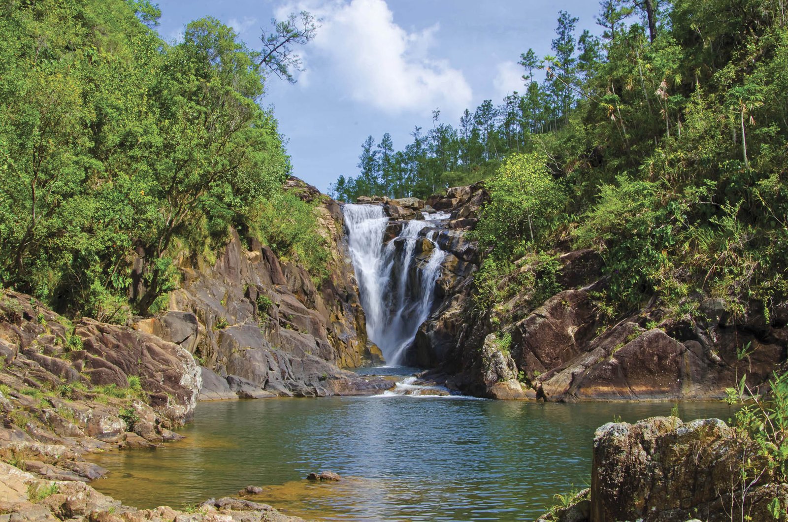
Today, in full recovery although suffering from the harshness of the weather, the forest serves as a preamble to the lookout from which you can see the Thousand Foot Fall, a waterfall that seems to be born of the foliage, plummeting to the green of the mountains. Some cabins in the area are rented to scientists interested in studying the fauna and flora of this area of Belize. The man in charge of the place and his wife live in one of the cabins. At night, the cold wind blows forcefully and sometimes they are awakened by the low growl of a cat that decides to wander between the houses.
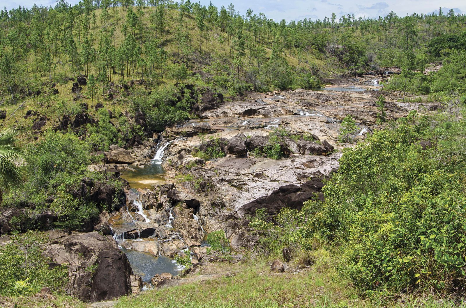
The Rio On Pools is the next stop, a sequence of small pools between the rocks. But it’s almost impossible to enjoy them when we arrive because it’s noon and the stone benches are burning hot under the sun. In any case, we stand for a while under some stunted bushes, looking at the scenery.
After our brief visit to Rio On Pools, we head towards Big Rock Falls, which I can assure you is the perfect place to wait for goblins. To get there, you have to go down some rustic steps from which you can gradually begin to see the waterfall. When the forest finally opens up, the river appears and, on the left, a stream of water plunges down a wall of rock ending in a misty pond. Further down a mirror is formed, large and clear. And since the sun has gone down a bit, it becomes the perfect moment to let the sound of the water enchant us.
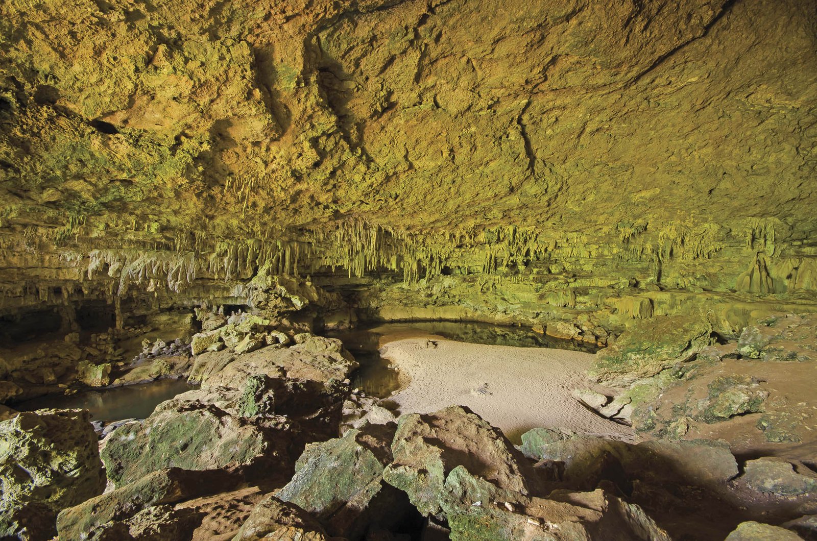
Now with the soul refreshed, it is time for the Rio Frio Caves. The ancient Maya believed that the caves were the entrance to the underworld. There must be some truth to that because the entrance to Rio Frio is wide and seductive, very different from the eye of the needle that the Bible promises for the righteous. Once inside, a running river gives the place a special atmosphere. Dora says that sometimes you can see fish in the pools, but today the water is just a bottomless blackness. Once again outside, a sharp sound surrounds us: it’s the song of thousands of warblers that, hidden among the branches of the pine trees, give us their melody of love and life.
Traveling to the Past
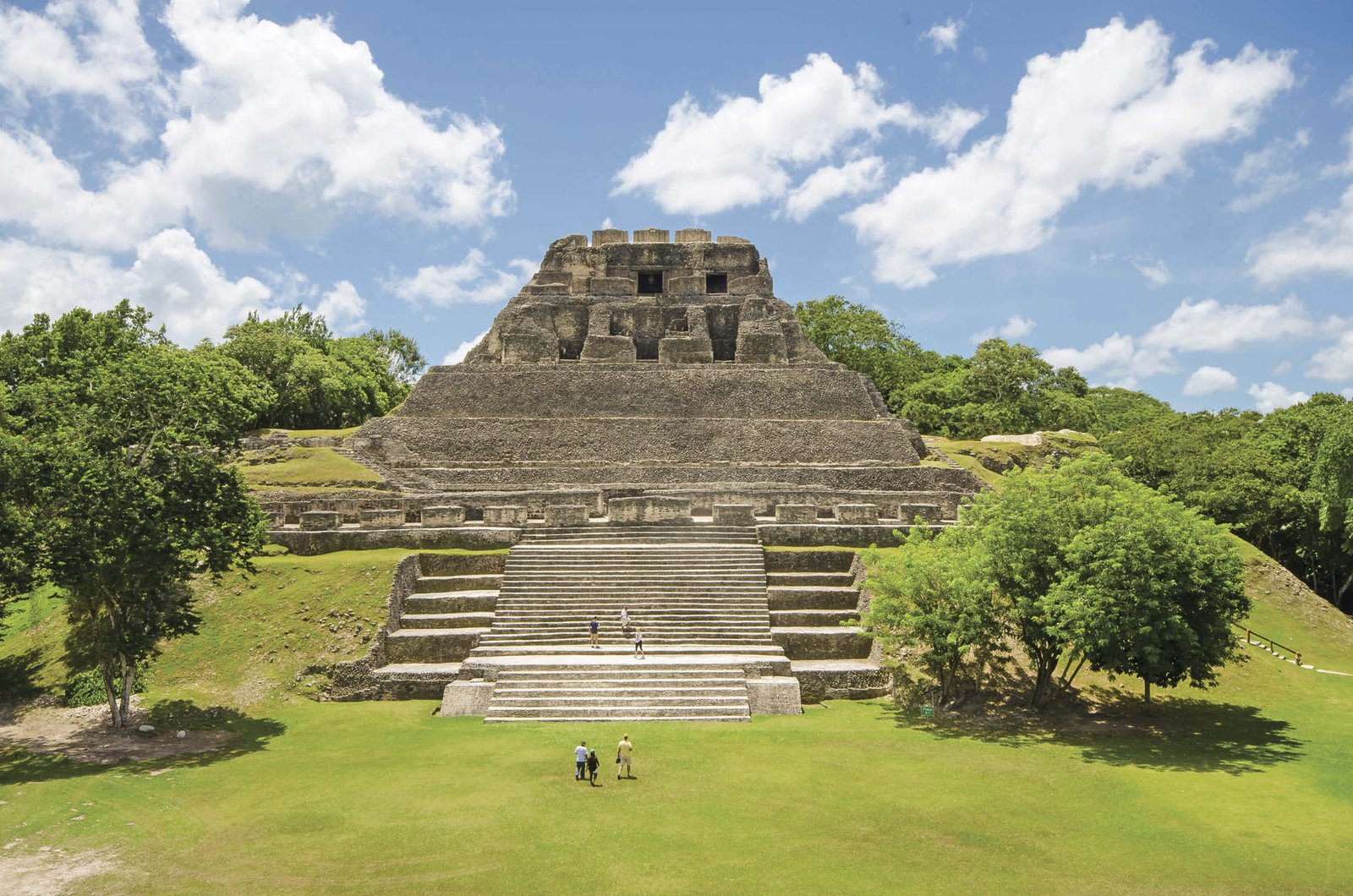
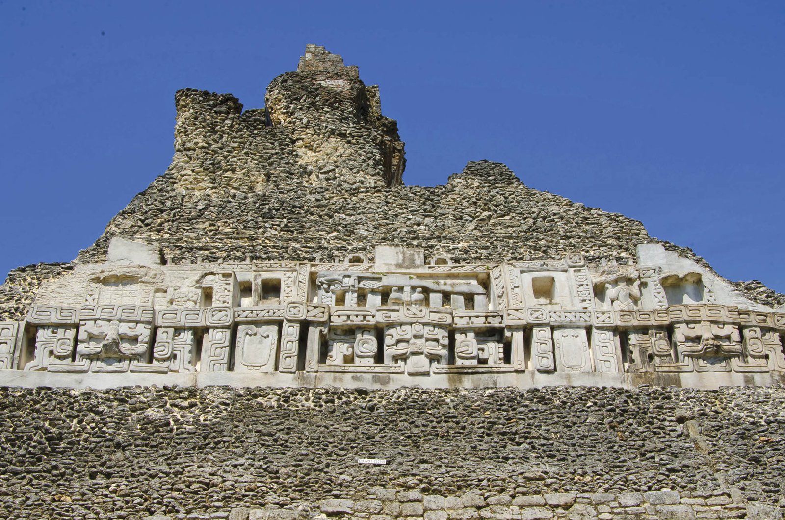
The plan for Thursday in Belize is to see some of the country’s Mayan ruins. Xunantunich, which means maid of stone in the Yucateca language, is one of them. To reach the site you have to cross the Mopan River via a three-minute ferry ride.
The British physician Thomas Gann conducted the first explorations in Xunantunich in the 19th century. The first photograph of the site on record was taken in 1904 and shown at the Peabody Museum of Archeology and Ethnology in Cambridge, Massachusetts. The activities remained on hold until 1924, when Gann returned and found many Mayan treasures, of which there are no records.
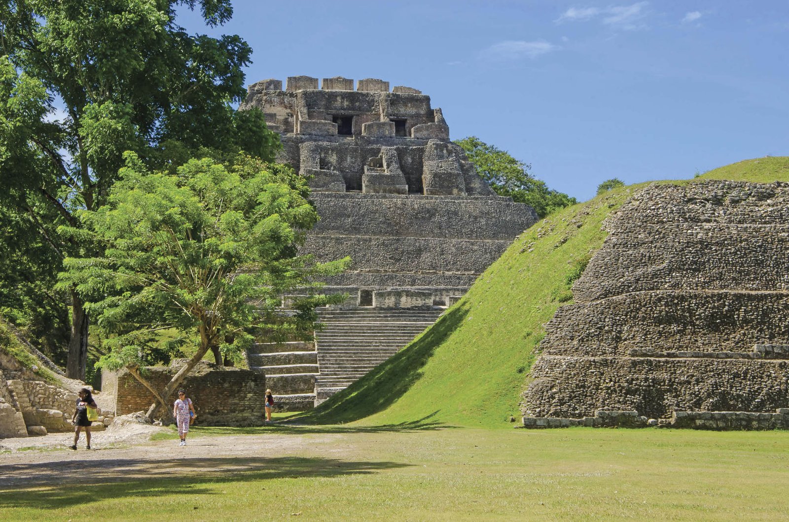
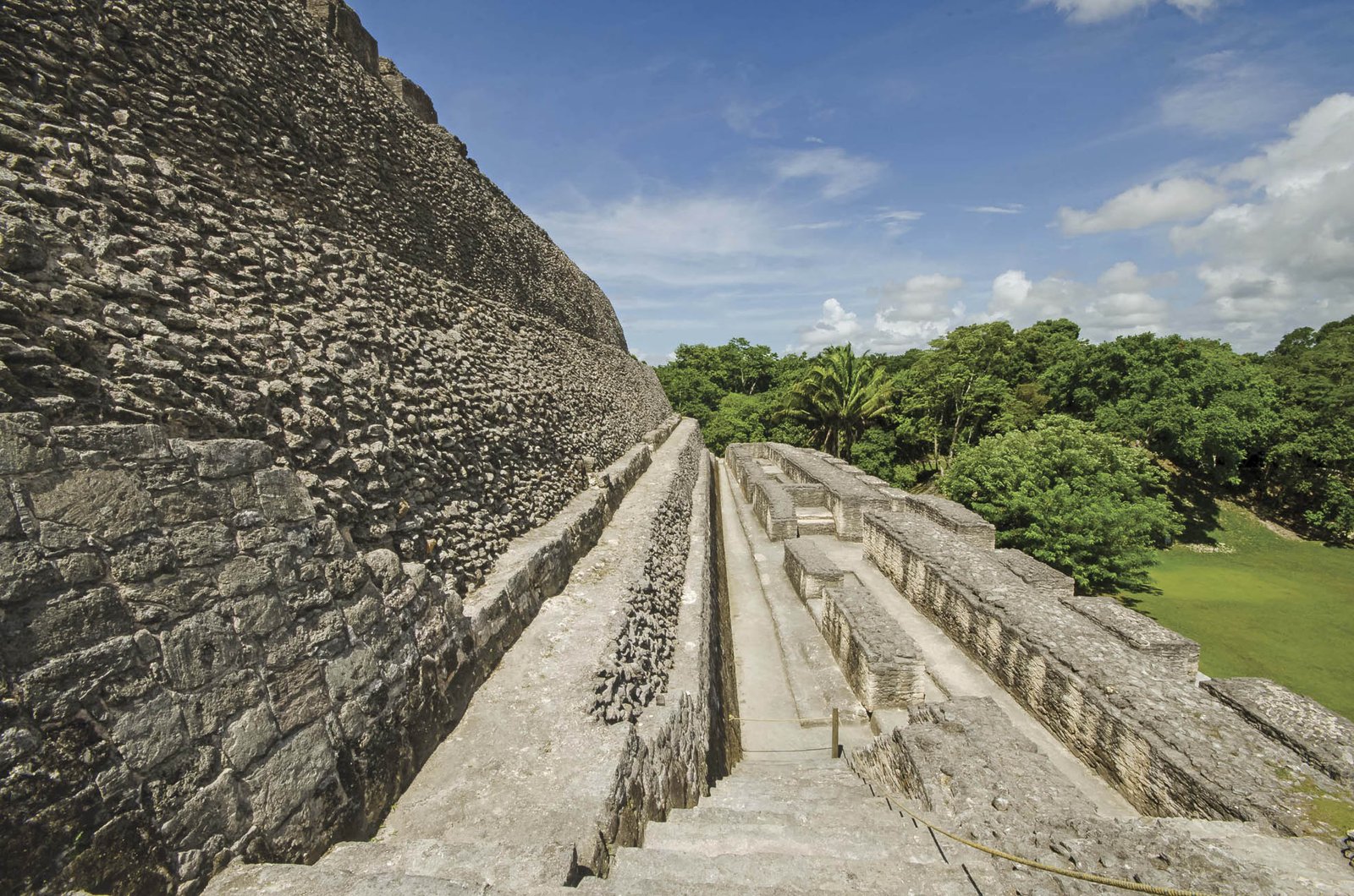
Since 1990, researchers from the University of California, under the leadership of Richard Leventhal, began an excavation and restoration project that is still going on today. Among their findings is the discovery that one of the most thriving periods of Mayan culture in this region occurred between the years 670 and 780 B.C., when Xunantunich was consolidated as one of the most important centers of the Belize River area. During this period, “El Castillo,” one of the most iconic buildings of the complex, was built. It is about 130 feet high, making it unsuitable for those suffering from vertigo. The complex also has a visitor center, which includes an explanatory model of the place, photographs, maps, artifacts, and the history of this ancient Mayan ceremonial and political center.
Meanwhile, in the foothills of the town of San Ignacio, there is Cahal Pech, another center of Mayan ruins with some thirty-four structures, including temples, palaces, and areas for their famous ball game, which was played during agrarian, religious, political, and social rituals.
Cahal Pech has no large buildings like Xunantunich, but there it’s possible to more clearly imagine what daily life was like in this ancient civilization, because housing areas have been preserved (with rooms, corridors, and passageways), and several interconnected indoor gardens. The research indicates that this place was inhabited until roughly 900 A.C., making it one of the oldest Mayan complexes in western Belize.
The day tour ends in the best way possible: delighting the heart with ceviche served at the Guava Limb Café, a restaurant in Morra Town, San Ignacio, in a house built in the best traditional Belizean style. The next day, our journey will take us to the beaches…
Getting There
Copa Airlines offers two flights to Belize City each week. To get to the Cayo district, renting a car is recommended. For more detailed information, please visit www.travelbelize.org
Where to Stay
Cahal Pech Village Resort, in the town of San Ignacio, has rooms and cabins overlooking the town, in addition to three pools, a bar and restaurant. The hotel staff can help you organize tours and walks.
Where to Eat
Guava Limb Café, a restaurant housed in a restored wooden house on stilts, is located in Morra Town, San Ignacio. The menu is generous and the ceviches are spectacular.
Benny’s Kitchen, in Benque Viejo del Carmen, is a popular restaurant offering traditional Belizean dishes, as well as Mayan, Guatemalan, and Mexican-influenced selections.
Interesting Facts
The border post between Belize and Guatemala is in Benque Viejo del Carmen. It’s a border that seems calm and empty, although the construction of a duty-free zone is planned.
While in Belize City you can hear a lot of reggae. In the towns of San Ignacio and Santa Elena, there are stations that broadcast Mexican corridos —and narcocorridos. Pay attention to the lyrics, they are a sociological experience.