

Tikal and Yaxhá. Testimonies of a Lost World
In the midst of a jungle that devours everything, the ancient capital of the Maya world reveals its history written in stone, its lost splendor, and the questions that still trouble archeology today.
- March 6, 2026
By Marcela Gómez
Photos: Alejandro Balaguer
The magic that surrounds a truly unique place.
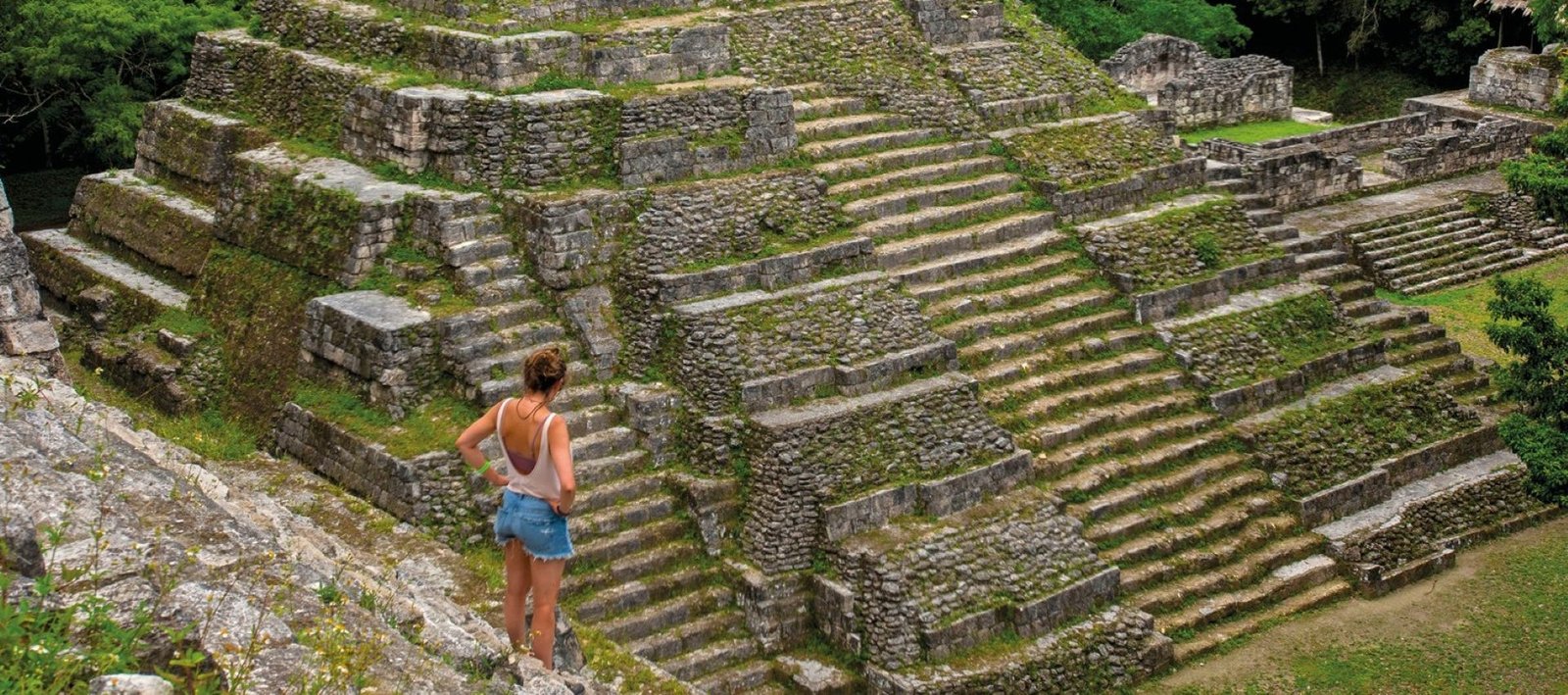
From the top of the Temple of the Masks in Tikal, Guatemala, I have a complete panoramic view of the Temple of the Great Jaguar, an emblem of the largest and most important city of the Maya world. Below, the dense jungle sways in the wind, while the electrifying roar of howler monkeys reigns over the scene.
Below, I spot Tikal’s only other visitor today: my teammate, photographer Alejandro Balaguer. While hordes of tourists crowd around Gaudí’s monuments in Barcelona or wait in endless lines to board a gondola in Venice, here I contemplate silent, empty fields.
Since the pandemic —and especially during this rainy season— Tikal has fallen off the mass-tourism map. It is truly a privilege to have one of the largest and most important archaeological complexes in Mesoamerica almost entirely to ourselves.
Tikal means “the place of voices,” a reference to the constant murmur rising from the forest.
Tikal: A ceremonial metropolis in the heart of the jungle.
Nearly 5,000 buildings, spread across an area of 16 square kilometers, attest to its importance. And yet, what I see today, from my location 40 meters above the ground, is only a tiny fraction of what Tikal once was. Only 5 percent of the site has been reclaimed from the jungle. The splendor of its central causeway —paved and painted in vivid colors— must be imagined, along with the women dressed in handwoven textiles and the hundreds of men carving stone or transporting blocks and provisions.
Pese a su tamaño y a sus decenas de pirámides y edificios ceremoniales, Tikal no era un sitio de habitación permanente. Desde el período Preclásico (1000 a. C.–250 d. C.), las construcciones de piedra tenían como única finalidad la ceremonial o ritual.
Despite its size and its dozens of pyramids and ceremonial buildings, Tikal was not a permanently inhabited site. Beginning in the Preclassic period (1000 BC–AD 250), its stone constructions served exclusively ceremonial or ritual purposes. Those who lived there on a regular basis were members of the ruling lineage, as well as officials, priests, warriors, artisans, merchants, servants, and slaves —that is, those who were necessary for the functioning of the state.
The history of Tikal—its rulers, wars, and moments of splendor—was carved into stone stelae, while monumental temples and structures still hidden within the jungle continue to guard the mysteries of the Maya civilization.

Stone Diaries
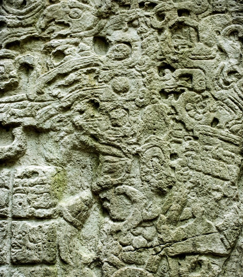
The story of what happened here —the rulers and enemies, the dynasties, and daily life— was written in stone. These are the famous stelae, carved at the end of a k’atun, or twenty-year cycle of the Maya calendar, and sometimes at its midpoint or quarter.
Although the first ruler is believed to have been Yax Ehb Xook in the first century AD, Stela 29 seems to provide stronger evidence for Chak Tok Ich’aak I, two centuries later. There are also indications that some rulers were women: Une’ Balam was particularly renowned, her name associated with that of a goddess.
When we arrive at the Lost World complex, our guide, Mario, shows us evidence of the arrival of the Teotihuacans —around the fourth century— and their domination of the city: a pyramid over 30 meters high, characterized by alternating sloping and vertical walls. Mario explains, however, that it was only after the fall of Teotihuacan in the year 695 that Tikal regained its independence, reaching its greatest splendor and resuming large-scale construction. Temples and pyramids became larger and taller.
Among Stelae and Temples: The Memory of Tikal.
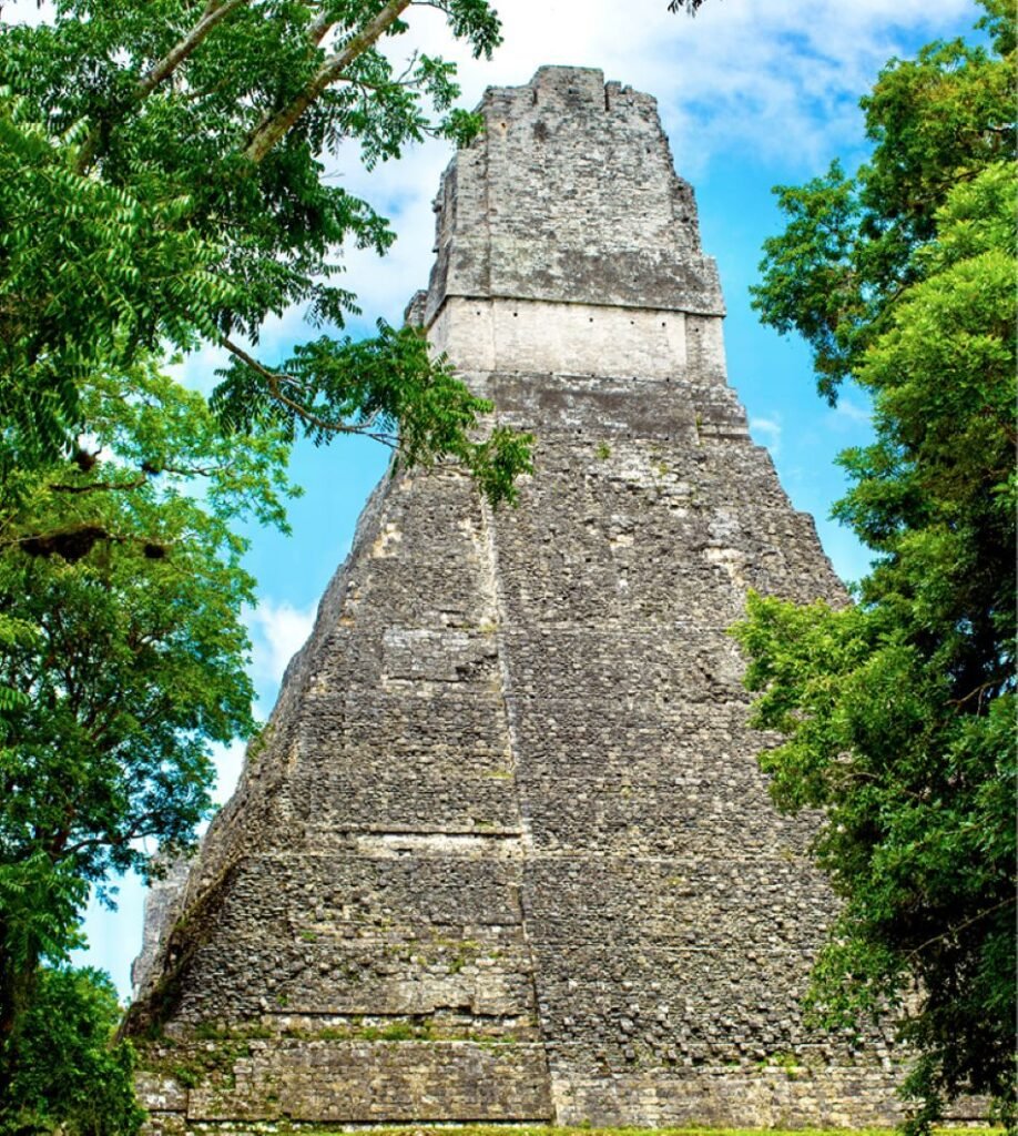
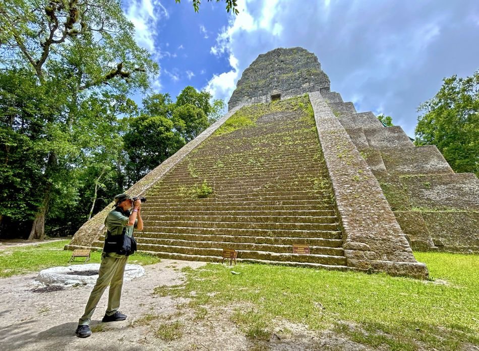
Jasaw Chan K’awiil was the architect of the military victory of 695 against this powerful northern kingdom. He was also the ruler who inspired the construction of Temples I and II. Temple I, standing 50 meters tall, is the favored icon of many admirers of Maya civilization; it is known for its stylized profile and vertical elegance. The tallest structure, however, is Temple IV at 65 meters, which, despite its monumental scale, remains largely covered by jungle.
Many of Tikal’s thousands of buildings have no known function. The numerous structures still hidden beneath the impenetrable jungle canopy may hold answers scientists have yet to discover.
Toward El Remate
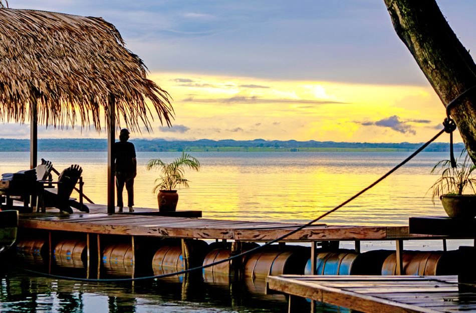
As the afternoon wanes, our guide quickens his pace. A car awaits to take us to El Remate, a modern village on the shores of Lake Petén Itzá. There lies our refuge, La Lancha. Far from tourist crowds and commercial circuits, we see this lodge as the ideal place to continue paying tribute to the lost Maya world.
cattered along a hillside and connected by winding paths, the ten cabins overlook the sacred lake. Their thatched roofs conceal interior luxury. We drop off our luggage in haste and, before the sky ignites in a spectacle of color, take the internal funicular down to the shore. There on the dock, before the celestial display of light, we wait for nightfall.
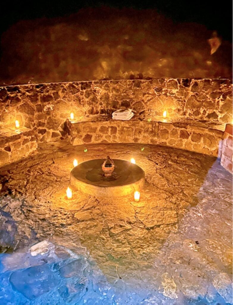
CWe end the day in the temazcal, a stone structure that mimics the maternal womb, created by the Maya for physical and spiritual purification. It is a relaxation ritual that uses steam and aromatic herbs. At La Lancha, created by the Coppola family as part of their exclusive collection of boutique hotels, the temazcal —built using ancestral techniques— is an essential experience.
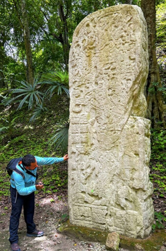
The stelae, temples, and pyramids of Tikal tell the story of its rulers, their battles, and their splendor, while the jungle still conceals many of its secrets.
A Biosphere Reserve
On our second day in Petén, we visit the ruins of Yaxhá (“blue-green water”), named after the lagoon stretching at their feet. This site, occupied for 16 centuries, once contained more than 500 buildings arranged along the Calzada de las Canteras and several paved transversal roads. The visit focuses on the Royal Palace, the North Acropolis, the astronomy complex, two ball courts, the East Acropolis, the Plaza of the Shadows, and the Twin Pyramid Complex.
Located within the Yaxhá, Nakum, and Naranjo National Park, a visit to these ruins is part of an experience that combines cultural heritage and natural patrimony under sustainable management that integrates local communities.
The ruins of Yaxhá, with more than 500 structures and centuries of history, reveal the splendor of the Maya world and the mystery of how these great cities were abandoned and eventually reclaimed by the jungle.
Yaxhá: Ruins, Jungle, and the Secrets of an Ancient Civilization.
As evening falls, we stand atop the Temple of the Red Hands. The sky, once blue, begins a display of violets that turn orange and culminate in a blazing red. I can imagine the monarch observing his domain from here. And the question that still troubles scientists today comes rushing in: what happened here?
The last stela carved in Tikal is Stela 11, dated to the year 869. Like the most unsettling Hollywood dystopia, these metropolises —which during the Classic period reached areas of up to 120 square kilometers and housed as many as 90,000 inhabitants— simply vanished. Was it overpopulation, deforestation, resource depletion, or internal wars? There is no single definitive cause. The cities were abandoned and the jungle swallowed the pyramids and palaces.
Will the world as we know it today disappear in the same way?
Tikal
Where is it located?
Tikal National Park, Department of El Petén, northern Guatemala (Maya Biosphere jungle region)
How to Get There
– Fly to Flores/Mundo Maya International Airport (FRS), then take ground transportation: 1–1.5 hours on a paved road to the entrance of Tikal.
– Tourist buses are also available from Flores and Guatemala City (via San Benito/Flores). We recommend hiring a certified guide and bringing water and sun protection.
5 must-see monuments:
- Temple I (Temple of the Great Jaguar) — royal tomb and iconic front view of the plaza
- North Acropolis — residential and ceremonial complex next to the Great Plaza
- Temple II (Temple of the Masks) — views toward the Great Plaza and Temple I at sunrise
- Great Plaza — ceremonial core with stelae and a high concentration of monumental architecture
- Central Acropolis / Palace — extensive complexes of courtyards, rooms, and administrative structures
Yaxhá
Where is it located?
Yaxhá-Nakum-Naranjo National Park, northeastern Department of El Petén, on the shores of Lake Yaxhá
How to Get There
– Fly to Flores/Mundo Maya International Airport, then drive to the site (approx. 1–1.5 hours depending on the route).
– Also accessible from Flores via combined tours with Tikal; some tours depart in the morning or late afternoon. We recommend hiring a local guide and visiting the lakeside viewpoint at sunrise or sunset.
5 must-see monuments:
-
- Main Plaza (Great Plaza of Yaxhá) — central complex with stelae and main pyramids
- Temple of the Serpent (Pyramid 216 or similar depending on local interpretation) — tall structure with excellent views
- Twin Temples Group — two adjacent pyramids representative of the site
- Acropolis and Palace — residential areas with stelae and complex architecture
- Viewpoint over Lake Yaxhá — panorama essential to appreciating the relationship between the city and the water.


Leave a Reply