Escudo de Veraguas
By: Juan Abelardo Carles
Photos: Carlos E. Gómez
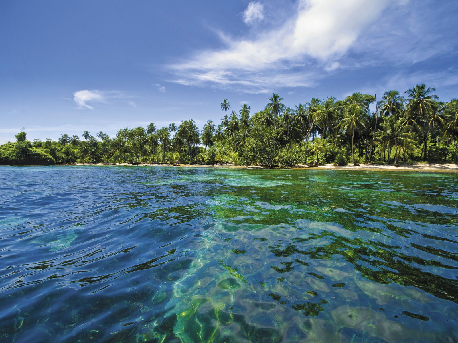
Bocas del Toro is one of the natural wonders of Panama. Innumerable islands, islets, and crags, including Colón, Cristóbal, Bastimentos, and Popa stretch almost to the Valiente Peninsula, enclosing a gulf dubbed the Chiriquí “lagoon.” The ocean currents are weaker here and mangrove swamps, reefs, and beaches jumble together to form one of the richest coastal ecosystems in the country and the Caribbean basin in general.
But north of the Valiente Peninsula, outside the lagoon’s protective arm, lies a lone island bravely facing the sea like the prow of an immense ship plowing through the Caribbean. In colonial times, it was named in honor of Columbus because it guarded the entry to the fief of Veraguas. The fief was granted to the admiral by the Catholic Kings, but neither he nor his descendents ever occupied it: the island´s name is Escudo de Veraguas, or Shield of Veraguas. Escudo pays dearly for its position on the front lines of the Bocas del Toro archipelago by being battered by powerful ocean currents without the support of its sister islands.
While reaching this natural sanctuary is not easy, it can be done and it is well worth the trouble. Early one morning, the Panorama of the Americas team found itself in the port of Chiriquí Grande– the easiest departure point for the island– haggling with local boatmen over the price of a trip to Escudo. The rate never includes fuel, and the trip can take up to ninety minutes, depending on the boat’s engine. We set off at nine in the morning, with favorable winds and a calm sea.

The first part of the journey takes us past the rounded hills of the Valiente Peninsula to the north. On the highest hill, on the peninsula’s outermost point (Bluefields), stand the remains of a fort built by the United States during World War I for sighting the enemy and providing a first line of defense against any invading force trying to approach the Panama Canal. We are accompanied by Horacio Trotman, a fellow journalist and native of this area, who explains that many of the surnames typical of the Ngöbe and the Buglé derive from soldiers billeted on the base at the time. The indigenous people lacked the Western concept of the surname but last names were required by the Panamanian government, so the indigenous people did not hesitate to borrow. Chosen surnames included Trotman, Taylor, Hooker, Robinson, Conelly, and Stonestreet.
The current grows stronger as we pass Bluefields point and leave the shelter of the Chiriquí Lagoon. We stop for a while at Kusapín, one of the largest villages in the Ngöbe-Buglé region. For such a small settlement, Kusapín shows an unusual level of activity: students from the local elementary school, patients from the health center, and fishermen resting after their morning labors swarm the village paths. Kusapín is a tourist destination in its own right, and paths leading to gorgeous beaches, forests, and mangrove swamps featuring a wealth of nature branch out from the town.
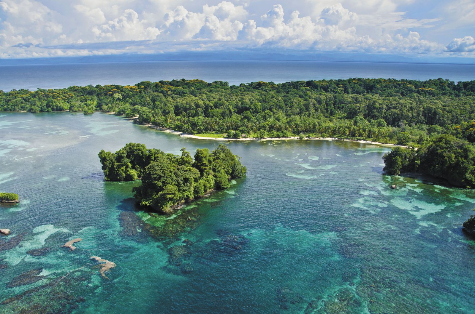
We are determined to press on to Escudo de Veraguas, so we board the boat again after buying some snacks. We finally have a sighting: the island, low and sometimes veiled by sea mist, seems to retreat from approaching travelers. Our first impression of Escudo does not fulfill the stereotype of a tropical paradise. Waves slap the shore of Escudo with destructive intent, demolishing crags, furrowing paths among the cliffs, and invading land beyond the coast. The result is a system of waterways that penetrates several dozen yards inland. At times nearly hidden by tall plants, the interconnected waterways seem like passages in an enormous natural labyrinth that could be the mansion of an ancient god, mysterious and perhaps sinister, like those worshipped by humanity at the dawn of civilization.

There are no permanent human settlements, merely temporary shelters for fishermen, who sometimes appear to have a mysterious, age-old aura that earns a certain respect. Geological data indicate that the islands of Bocas del Toro and much of the nearby continental landmass began to form twelve million years ago, making this the oldest part of the country. The history of Escudo is often found in traditional oral myths. It is said that before 1492, when the ancestors of the Ngöbe-Buglé reigned here, the suquias (sorcerer-kings of old) fought battles, armed with weapons from this world and the next, for control of the rich and flood-prone wooded flatlands. The victorious suquias had the magical ability to banish the souls of enemies killed on the battlefield to that far distant isle that appeared and disappeared on the horizon like a monstrous hallucination.
During the era of European colonization, legend has it that the island protected the last Misquito warriors of an early 18th century invasion that eventually threatened all of Panama, even reaching behind the Pacific coast mountain ranges. Descendents of indigenous peoples and Africans from the Caribbean coast between Nicaragua and Honduras, the Misquitos—buoyed by Great Britain— always resisted Spanish domination in Central America. After harrowing efforts, the Misquitos were repelled and contained, and in the last decade of the 19th century, they were finally overpowered by the governments of Nicaragua and Honduras, where their descendents now live.
We reach Playa India, on the island’s northern side, the only feasible entry between the long coral reefs that guard the Escudo seabed. A fisherman named Virgilio cleans the fruits of his morning fishing with the help of his sons and sons-in-law. We disembark and ask him about the rumors we have heard: the gigantic anaconda no one ever sees, but is clearly audible as it slithers along the ground, causing vibrations; and boats that inexplicably slip their moorings, unless they are tied with ropes made from a special vine that must also have been blessed by Ngöbe shamans.

“I’ve never heard anything like that,” Virgilio answers sharply, but in the face of our disappointment, he admits: “What does happen is that we hear outcries, as of many people shouting at the same time, whenever bad weather is going to blow in from the sea.” Might these be the souls of the banished? Fortunately, the weather is fine today. While Virgilio’s wife prepares a substantial lunch of fried fish and roast plantain, he and a grandson guide us along the rough tracks of earth and water that lead into the forests of Escudo.
We spot the dour and hairy bulk of a sloth in an enormous trumpet tree: this three-toed pygmy sloth (Bradypus pygmaeus) is native to the island and found only on Escudo de Veraguas. Being so far from the mainland, island fauna has naturally developed differences from its continental counterparts; the lack of serious predators resulted in smaller animals. Along with the sloth, a hummingbird (Amazilia handleyi) is also native and unique to this tiny enclave. Green sea turtles (Chelonia mydas), hawksbill sea turtles (Eretmochelys imbricata), and leatherback sea turtles (Dermochelys coriacea) come to Escudo to lay eggs.
We occasionally climb out of the boat to feel the barely perceptible white sand. The crystalline water is hip deep, making it difficult to walk, and shoals of young fish flee before us. The nooks and crannies of this natural labyrinth comprise a perfect incubator and hatchery for innumerable fish (snapper, bigeye trevally, and grouper) and shellfish (pinkspot shrimp, lobster, and several species of crab). Fishing here is (or is supposed to be) limited to artisanal efforts, and the Panamanian government has created a Protected Area around Escudo.
Dusk falls, and although it would be wonderful to camp here, we do not have the necessary equipment, so we reboard the boat and head back to the mainland. The return carries us past Boca del Río Caña, where the Ngöbe-Buglé Association for the Protection of Natural Resources (APRORENANB) has been spearheading an 8-year-old community initiative that attempts to save the nesting sites of the hawksbill, green, and leatherback sea turtles on the long beaches that start here and border almost the entire Gulf of Mosquitos.
The beaches are followed by the immense Damani-Guariviara wetland, a Ramsar site, which can be reached by hiring guides in Boca del Río Caña. This is one of the most beautiful parts of the country. Bands of howler monkeys enliven the landscape and lucky visitors may catch a glimpse of the elusive and endangered West Indian manatee (Trichechus manatus). Ngöbe mythology holds that mangroves and other plants can move at night, thus creating a different panorama every morning.
The inbound journey to the port of Chiriquí Grande is very different from the outbound: the mid-day heat has generated enough humidity to load storm clouds, which bear down on the coast, driven by a mountain wind. Even so, the setting sun manages to peep through the clouds and bestow upon us a rainbow that seemingly rises from the sea in the midst of a lovely landscape in which Escudo de Veraguas hides beyond the horizon. The island once again draws the veil of sea mist and twilight shadows across its face, continuing to exist in that illusory space between myth and legend.